Best Scenic Drives in Queensland
Queensland is a large and incredibly beautiful state. From the rainforests of the tropical north to south east coastal roads, windy trails through the scenic hinterlands and as far as the sparse farmlands out west, Queensland is a diverse place with something to satisfy everyone.
The best way to really explore Queensland is to hop in the car and take a scenic drive, stopping whenever a lookout, national park or attraction catches your eye.
We’ve put together some of our favourite Queensland scenic drives together to give you an idea of what to do on your holiday. Pick the drive and region you want to explore, or join all the drives together for an epic Queensland road trip.
Blackall Range Tourist Drive
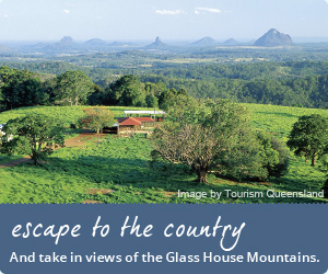
 Just inland from the Sunshine Coast you’ll find a beautiful hinterland drive up in the Blackall Range. There are a number of quiet little townships up in the mountains enjoying spectacular views of valleys and the Sunshine Coast, Bribie and Moreton Islands off in the distance.
At 550 metres above sea level the air is cooler, the grass is greener and local produce tastes so much better. You’ll discover art galleries, wineries, cafes & restaurants, rainforest walks, markets and even a traditional cheese factory where you can taste to your heart’s content.
Starting from Mooloolaba on the Sunshine Coast, take the Sunshine Motorway to the Bruce Highway heading south and take Steve Irwin Way out to Landsborough. From here follow Landsborough-Maleny Rd until you see the signs for the Blackall Range tourist drive, and make sure you stop at the townships of Montville, Mapleton, Cooloolabin, Maleny and the lookouts along the way. The tourist road loops around back to Landsborough-Maleny Rd where you can retrace your steps back to the coast.
Total Distance: 60km to rejoin Landsborough-Maleny Rd
Duration: 1 hour
Region: Blackall Range
North Queensland Great Tropical Drive
 The Great Tropical Drive is an amazing experience and takes around 12 days and travels over 2079 kilometres starting from Cairns or Townsville.
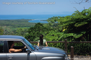
The Great Tropical Drive is a self-drive route that takes you through the Daintree Rainforest, the sleepy town of Port Douglas, Cooktown and many many of Tropical North Queensland's gems.
Over the 12 days you'll get to travel past the Great Barrier Reef, journey through the Daintree Rainforest, Cooktown, Charters Towers and finally arrive in Townsville.
Along the way you'll meet interesting local characters, eat some excellent local produce, pass through quaint townships, rolling fields and some of the most beautiful scenery you'll ever see. You don't have to do the full 12-day drive either - the Great Tropical Drive can be broken down into smaller trails that take you through a particular town rather than going the whole distance from Cairns to Cooktown.
Total Distance: 2079km
Duration: 12 days
Region: North Queensland Coast
Map of Drive Route
Gold Coast Hinterland - O'Reilly's & Lamington National Park via Canungra
 Take in some of the Gold Coast's more historic areas and make a trip to Lamington National Park. With plenty of twists and turns around the mountains, this scenic drive is certainly one you can take as slow (or as fast, within the speed limit) as you like to really enjoy the views.
Starting in Surfers Paradise, follow the signs to Nerang and then Hinze Dam. About 5 minutes out of Nerang you'll see a turn off to Mount Tamborine and Canungra. This road stretches along to a historic river mill on the right and Mount Tamborine on the left (also worth a visit!), but just continue along and follow the signs to Canungra and you'll be heading in the right direction.
Leading you past scenic hills and dales, rivers and wineries, this road will take you past the Canungra Army Base through a more rugged and hilly section. Once you get to town it's worth a stop to explore and stretch your legs. The local pub, quaint cafes and parks make for a great spot to stop for lunch. Next is the trip to O'Reilly's, which is a beautiful guesthouse at the top of the mountains in Lamington National Park. Enjoy dozens of different bushwalking trails, more cafes and restaurants and just take in the fresh air!
Total Distance: 80km
Duration: 60-120 minutes
Region: Gold Coast
Central Queensland
 What better place to start a tour of central Queensland than Rockhampton; the beef capital of Australia. From here head west through farmlands and National Parks to Emerald; gateway to the Sapphire Gemfields. There are beautiful botanic gardens in Emerald, as well as an art gallery, fossilised tree and a fascinating museum.
For the next leg of the journey keep going west until you hit Longreach, where you can visit the Australian Stockman’s Hall of Fame, as well as the Outback Heritage Centre and the Qantas Founders Outback Museum.
Returning east take a right turn in Barcaldine (the location of the great shearer’s strike that led to the formation of the Labor party), through Blackall and on to Carnarvon National Park. You could spend days exploring the 30km chasm of Carnarvon Gorge. The white sandstone cliffs give shelter to a range of tropical plants and you can even find Aboriginal rock art if you keep your eyes open.
The journey back to Rockhampton now takes you through the agricultural heart of Central Queensland. Check out the fields to spot cotton, sorghum, wheat, herbs and spices that are sent all around the world.
Spend a couple of days just doing an individual leg of this tour or take a couple of weeks to really enjoy the sights and take in the history of Central Queensland.
Total Distance: 1,865 km
Duration: 24 hours
Region: Central Queensland
The Scenic Rim
Heading away from the coast, the Scenic Rim of south Queensland is a spectacular regional area full of tradition, colonial history, wine, scenic views, National Parks, and more wine.
There's no official Tourist Route through the Scenic Rim but there doesn't really need to be. There are plenty of things to see and do throughout the region and whichever road you take to get there, you'll find stunning views along the way. We've put together our favourite route but you can have just as nice a drive if you pick a spot on the map and simply wing it.
Starting in Brisbane head south towards Veresdale where you’ll see uninterrupted views over the Logan River flood plains. Keep going on to Beaudesert where there’s a Historical Museum, Arts & Information Centre and even an annual Country & Horse Festival held in June.
Following the Mt Lindesay Highway after Beaudesert you’ll come across Rathdowney where you can stop at the Captain Cook Lookout or head in to Mt Barney National Park to explore the mountain tracks. Driving on the highway climbs up to the ridgeline of the McPherson Ranges, which aren’t just spectacular views, they form the border between Queensland & NSW.
Turn down the Richmond Range to follow Summerland Way alongside Mt Lindesay National Park. The mountain is a remnant of what was once a massive extinct volcano called Focal Peak. You can get some great photos of the peaks but your best shots come from hiking your way to the top of the mountain.
Follow Summerland Way until you can turn left on Lions Road which passes through the exquisite Border Ranges National Park. You’ll find lookouts in the park that allow you to see all the way out to Mt Warning and the sea. Follow Lions Road until it connects back up to Mt Lindesay Highway and follow the way you came back into Brisbane.
Total Distance: 314 km
Duration: 4 hours 30 minutes
Region: Scenic Rim (south east Queensland)
The Savannah Way – Cairns to Normanton
The Savannah Way is one of Australia’s most epic adventure drives. Stretching the width of the northern region of the continent, the route links Cairns in Tropical North Queensland with Broome in Western Australia. The full 3,700 drive takes you well out of Queensland but you can easily stop and turn around in Normanton to make the most of the Queensland portion of the journey.
Starting in Cairns, take the Kennedy Highway up to the tableland township of Atherton where you’ll find a wonderfully temperate climate, tranquil rainforest walks, scenic lookouts, wineries and a sleepy mountain township.
Keep following the Kennedy Highway as the landscape changes from rainforest to something more like an Australian savannah. Make sure you stop in at the Innot Hot Springs on your way to Forty Mile Scrub National Park. Even if you don’t stop at the National Park, pay attention to the open grassy woodland and unique views created by ancient volcanic flows.
A few kilometres after Forty Mile Scrub you’ll need to turn right onto Gulf Developmental Road. Keep following this road to pass through Mount Surprise where you can try your hand at fossicking, Georgetown where there’s a world-class mineral collection, admire the sandstone cliffs of Cobbold Gorge, walk the historic streets of Croydon Historic Village and from there drive the 4km off route to take a refreshing dip at Lake Belmore.
Finally you’ll pull into the town of Normanton where you can explore its historic past or even ride the Gulflander Train. From here you have the choice of turning around and heading back the way you came, exploring everything you missed on the way, or charge on through Northern Territory and Western Australia to finish in Broome.
Total Distance: 683 km
Duration: 11 hours 15 minutes (allow a week to really take it all in)
Region: Far North Queensland
Overlander's Way
Overlander’s Way follows the paths of the drovers, where they brought large herds of cattle from the Kimberly to the Queensland east coast. Back then it was a hard route that took weeks, required some navigational skill and a whole lot of supplies. Today it’s a sealed road with a number of outback towns and rich history to enjoy along the way.
Departing from Townsville, you’ll take Flinders Highway to Charter Towers, a town that was once the second largest city in Queensland at the height of the Gold Rush. Stop here a while to appreciate the fortunes people sought and follow the Ghosts of Gold Heritage Trail.
Continue along Flinders Highway as it passes through White Mountains National Park and on to Hughenden. Millions of years ago this town was the shore line of the great inland sea. It’s also where the first complete dinosaur skeleton was found in Australia. ‘Hughie’ is still on display at the Flinders Discovery Centre.
If you keep on droving you’ll get to Julia Creek, the first European settlement in north-west Queensland and once a major stopping point for drovers. As you pass through Cloncurry the Highway becomes Barkly Highway for the final leg on to Mount Isa; mining town and outback oasis!
Mount Isa marks the end of this Queensland road drip but the original Overlander’s Way went on for another 660km to Tennant Creek in Northern Territory. From here you can finish the old route or turn around and head back in to Townsville.
Total Distance: 900km
Duration: 9 hours 45 minutes (allow a week to really take it all in)
Region: Gulf Country
Sunshine Coast - Coastal Drive
There are some beautiful beaches on the Sunshine Coast with ocean views that stretch as far as the eye can see. It’s the perfect place for a coastal drive through sleepy beach communities and pristine picnic locations.
Starting in Caloundra take Nicklin Way heading north. You’ll pass along the luxurious canal estates of Kawana Waters before turning right on Brisbane Road then left at Beach Terrace to follow along the beaches of Mooloolaba and Alexandra Headland. There are plenty of walking tracks to explore, beaches to swim and parks to rest at on this stretch of coast.
This road eventually turns into Duporth Ave and later Bradman Ave as it runs along the banks of the South Maroochy River. When you get to the Sunshine Motorway take it north for a short spell until you can take the Marcoola exit on David Low Way. This road will take you along Marcoola’s piece of coastline. This is perfect for anyone who’s ever claimed to enjoy ‘long walks along the beach.’
From here you have nothing but beach side driving ahead as you pass along Coolum Beach, Peregian Beach, Marcus Beach, Castaways Beach and Sunrise Beach, finishing up at Sunshine Beach. Take this time to enjoy the ocean views to the right, as well as Noosa National Park on your left. You’ll be surrounded by picture perfect Australian scenery so don’t forget to bring a camera.
You can either turn around and go back the way you came, or keep following the road north into the popular area of Noosa Heads.
Total Distance: 55km from Caloundra to Sunshine Beach
Duration: 1 hour
Region: Sunshine Coast